The hike we won’t forget
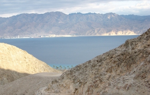
The sun’s rays bathe the Edom Mountains across the Red Sea. From here can be seen three countries bordering Israel: Jordan, Saudi Arabia and Egypt
These three days will remain in the mind of most people for a very long time. They were during the biggest snowfall in Jerusalem for nearly 100 years, and heavy rains in the southern part of Israel that exceeded 200mm.
On Thursday morning the pickup bus left Raanana at 04:00 and eventually picked me up at Kastina (just 4kms from Moshav Orot) at 05.10. We stopped at Lehavim, Beersheba and Omer, and by 06.30 we were on our way for our first hike of the day in the HaMaktesh HaGadol (the Big Crater). This is a geological erosional landform of Israel's Negev desert, measuring 5 by 10 km, with steep walls of resistant rock surrounding a deep enclosed valley.
At 07.30 we were walking up Mount Saharonim, and then downhill until Ein Saharonim (Crescents Spring) which is a small contact spring. Here we stopped for a well-earned breakfast. It was desperately needed as some of the hikers had started their day at 03.00 in Jerusalem so they could drive to Raanana to join the bus. We then walked along Nachal Gvanim, a beautiful walk, until we rejoined our bus.
Our next stop was Maale Shaharut, and there we walked along the cliffs until the Maale Zugan, and then headed down the trail to finish near Kibbutz Yotvata. Due to the cold weather we walked much faster than usual, and so arrived at a camp site at 16.00, which gave us time to put up our tents and prepare the soup which makes our main evening meal. We were lucky that there was no wind that evening, although it was pretty cold. We had our usual camp fire with songs, and bottles of wine doing the rounds. After the soup, nuts and fruit were also passed around and a pleasant hour was spent. We headed for bed early. The day had been extremely long and we had walked over 18 kms. I was very comfortable in my little pup tent as the bus had also carried my blowup mattress.
Next morning we were up at dawn - 06.15,- and devoured coffee and cakes before starting the ascent of Nachal Yotvata at 07.45. We had been warned that the day would be long - over 20kms with steep ascents and descents. Believe me, it was steep, climbing up and over rocks using the rope I was carrying to assist people on the harder parts. After a short break for breakfast, we were at the top. What a climb, and well worth it.
Our next aim was to get to the top of Mount Argaman, and that was something unusual as it wasn't the usual rock climb but lots of wet sand and it was very steep. Once up there, the view from the top was 360 degrees and unbelievably beautiful. From the top of the ridge and all the way to the top of the Argaman we were witness to something beautiful and unusual - snow on all the peaks of the Jordanian mountains. No words can describe the beauty of those scenes. From the top we then had a treacherous downhill descent, with our hearts in our mouths. We felt that at any moment we would just fall all the way down.
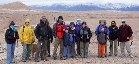
Our intrepid hikers with the snow-capped Jordanian hills in the background
Little did we know what was awaiting us towards the bottom of Mt. Argaman, and then the descent down Nahal Argaman, which we had been told was steep and hard. Firstly the rain had started to pour, and the winds were very strong practically blowing us off our feet. We arrived at the top of the cliff and were nearly blown off the edge, but others had already started so off we too went, always two together, for both moral and physical support. It was a long murderous descent on one's knees. We stopped near the top when we found a good overhang to shelter us from the rain while we ate our lunch. It was a cold and wet lunch but spirits were high and nobody complained. Eventually at the bottom we all met up again, as we all had different speeds going down, and we started the long trek back to our bus. It was a more than 20 km walk back to the camp site, where we were given a much needed hot tea made by the driver. It was 16.40, almost dark. We had been on the go since 07.30; a long, hard day, but special in a way that is impossible to explain if you hadn't done it yourself. As it was nearly dark we prepared our soup. After the soup and a bottle of wine we went to bed was just too cold and windy to sit outside like the previous evening.
Next morning we were once again up at 06.30. What a beautiful day it was, with lovely clear skies, and the air was so nice and crisp. We had morning coffee and cakes, and then broke camp and packed all our belongings in the bus as we would not be returning to this spot. Before 07.00 we were in the bus and heading towards Eilat. Our destination was the new fence put up between Egypt and Israel where once again we would be allowed to walk along the beautiful canyons that had been closed off to us for the last few years. Unfortunately, when we arrived at the part where we had been promised that the way was to be open, the army stopped us. The IDF soldiers said that the fence, despite all the promises, was not yet completed and that the path to Nahal Safra was closed. Never worry - our guide, Ilana, then took us on a detour with a fairly hard drop to the canyon, and we hiked up the canyon and then down once again, so that we missed nothing but did quite a bit of extra walking.
We did the climb up Mt Shlomo and then headed for Nahal Gishron which has cliffs of limestone and chalk, and was excellent with its beautiful granite formations.
We crossed the saddle of the Gishron where we reached the "Knife Trail" which has a vertical drop to the East. From there we had a complete view of the new fence along the Egyptian border, plus lovely views of the Red Sea with the Saudi Arabian peninsula in the distance. As we made our way down the trail we saw the limestone bulbs both loose and embedded in the stone. There are lots of theories as to how they have been formed, but no true answers.
Our trail now left the sedimentary rock of the Gishron Fault and led us to Nahal Tzefahot, where we arrived at the ideal time (late afternoon) for the sun's rays to bathe the Edom Mountains across the Red Sea in a unique reddish light. From this position we could see three countries which border Israel: Jordan to the East, Saudi Arabia to the south-east and Egypt (Sinai) to the south-west.
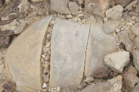
Limestone bulbs both loose and embedded in the stone
Our walk was now drawing to an end and we took the trail running south of Nahal Garinit, leading to the Eilat Field School where we finished our walk. By 16.00 we had reached our destination where we enjoyed cake, coffee or tea, and then began the long drive back home. The swim that we had thought about was out as it was way too cold and we were later than expected due to the extra walking.
And so we finished another 3-day hike, colder and wetter than we had anticipated, but with wonderful memories. I can't wait for the next hike.
I have been participating in the annual 3-day hike in the Eilat mountain area with the Raanana group that I have been walking with for the past two years. We do one 3-day hike, three 2-day hikes and three 1-day hikes in the period from late November till end of April. Last year Mark Kiel, a member of the ESRA group, joined us, and I hope that he enjoyed this rather challenging hike as much as I did despite not having the best of weather.


Comments