Reminiscences: A Walk in Nahal Poleg Nature Reserve
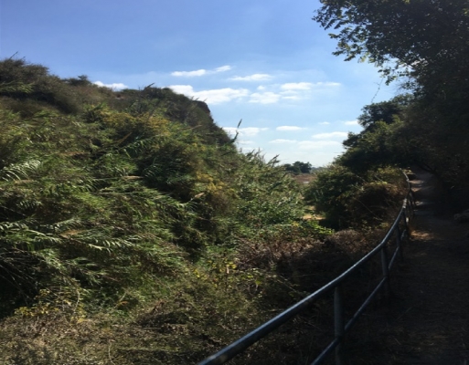
The Roman Gate
As we enter this year of Shmitta* my mind is inextricably drawn back to the last Shmitta year and my early days as a tour guide.
The first outing I guided was for ESRA Netanya, which if truth be told took place a few months before I passed the Ministry of Tourism final exam. It was planned as a simple walk for local ESRA members round the nearby Nahal Poleg Nature Reserve, intended as an appreciation of what was on our backyard.
As well as a first for me, this was to be the first of many subsequent outings for ESRA Netanya.
Meeting in Ramat Poleg, just south of Netanya, we started our walk heading east following a mud track under Route 2. On the other side of the highway we entered Nahal Poleg Nature Reserve which runs between the two limestone** land ridges running north/south along the Israeli coastline. Situated between the Wingate Institute and Ramat Poleg and between Highway 2 and the Mediterranean the Nature Reserve covers some 500 dunams and was declared such in 1971.
On entering the Nature Reserve, we passed the Poleg River, a short section of which passes through the Reserve. One of the smallest of the Sharon coastal plain streams, it starts out in the Hamra Hills just east of Mishmeret between Tira and Ramat HaKovesh. It runs west towards the sea, veering north at Batzra. While mostly intermittent, the stream does come in to its own, primarily after the winter rains, as it runs into the Mediterranean.
We followed one of the two marked circular trails which are also open to riders on horseback and cyclists. These trails introduce one to this beautiful Mediterranean seaside reserve. The length of each trail is limited to about 2 km, and they include a total climb and descent of only 35 meters or so.
After a ten-minute walk, we reached the Grove of the Three planted by members of nearby Moshav Udim in memory of three of their members who fell while defending the settlement in 1948. The grove of eucalyptus trees is also a meeting point for the trails as well as the Israel National Trail (Shvil Yisrael) which passes through the Nature Reserve.
We enjoyed seeking out the varied plant life which combines Mediterranean species such as fragrant, thyme, winter-blooming spiny white broom, boxthorn, dark-purple iris blooms, lupin, Rumex rothschildianus (named for Baron Edmund de Rothschild), and the biblical, deep red tulipa agensis. We passed groves of planted citrus trees and even stopped and picked almonds.
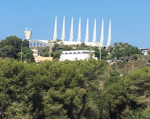
View of Wingate Institute
The fauna in the Reserve reputedly includes porcupines, rabbits and gerbils, the occasional fox and even badgers, although we saw little.
We climbed atop the second limestone ridge to see the remains of the Tel Poleg archaeological site. Although much of the site was destroyed by limestone mining in the early 1950s, a settlement from several periods was exposed during the subsequent excavations of 1959 and 1964.
From our viewpoint, we could appreciate how the ridge presented an impassable obstacle for the small stream flowing from the east and how swamps accumulated behind it and how the subsequent man-made rock-hewn breach in the limestone ridge enabled the water to flow through on towards the sea.
Excavations reveal that the first settlement in the area was a fortified city of the Canaanite period in the Middle Bronze Age (about 3,500 years ago). At that time, the bend of Nahal Poleg around the limestone ridge was used to build a fortress surrounded by a thick wall. A large brick tower was discovered in the southwest wall. A moat was probably hewn, which provided the foundations for a gap in the limestone ridge.
The ancient settlement did not last long, but settlement in the area was renewed in the Iron Age (3,000-2,900 years ago) and lasted intermittently until the Byzantine period. It is commonly assumed that the ancient moat at Poleg Gate was expanded in the Byzantine period and is now consequently known as the Roman Gate. The breach was created to allow water to flow and prevent the creation of marshland. This breach is what gave the Poleg stream its name.
The Crusaders called the stream, River Rochetaillé ("Split-rock River"), because of the long narrow rock channel cut artificially through the ridge. On September 6, 1191, the night before the Battle of Arsuf, the Crusaders camped near the mouth of River Rochetaillé; by then, the opening in the ridge had clogged again, resulting in a 4000-dunam marsh, which protected the Crusaders' camp from the east.
The swamps remained intact until 1935 and the opening was only cleared during the drainage works during the British Mandate period and later in the 1950s. It was then that the stream's current course was set in the area east of the limestone ridge. The marsh, known by the Arabs as Birkat Ramadan, remained south of Tel Yitzhak as late as 1945, and was a popular hunting location with abundant wildfowl.
From the vantage viewpoints on either side of the Roman Gate we could see the other side of the breach, the hinterland, Wingate Institute, and Netanya.
The abundance of local flora with a stop atop the historic Roman Gate, through which Nahal Poleg flows on its way to the Mediterranean, makes a visit to the Nahal Poleg Nature Reserve a must, especially suited for family hikes. Moreover, it is close to the central district and does not require a long drive.
I am sure every guide remembers his first guided tour and I am no exception. I had planned the walk meticulously to appear seamless and natural but, in reality, I was a bundle of nerves. Once I got over the initial panic I went into guiding mode as trained and all went well. I handled the inevitable nudnik calmly, politely and with panache and was not even fazed when we lost two participants.
So, what brought back all these reminiscences?
One of ESRA Netanya's members and resident poet, Susan Olsburgh, recently forwarded a poem, a villanelle, which she wrote at the time, entitled 'Hinterland'.
Not every aspiring guide is honored with a poem written about his first trip!
Hinterland
By Susan Olsburgh
You led us to our local hinterland,
newly qualified guide with Jewish ties
exploring places you had clearly planned.
We crossed the river, estuary and sand
and surveyed with ever widening eyes.
You led us to our local hinterland:
One of the most striking scenes soon at hand
melons lay on a field scattered like flies,
exploring places you had clearly planned.
Yeah! Shmitta* a year of rest for the land,
our farmers' faith, new crops will yet arise.
You led us to our local hinterland.
Here we saw seventh year of farming banned
clearly evidenced, fruits of every size,
exploring places you had clearly planned.
A casual day's saunter helped me understand
complexity of faith for G-d so wise
You led us to our local hinterland
exploring places you had clearly planned.
* in the seventh year, the land shall have a complete rest, a Sabbath to the L‑rd; you shall not sow your field, you shall not prune your vineyard, nor shall you reap the aftergrowth of your harvest . . . And [the produce of] the Sabbath of the land shall be yours to eat for you, for your male and female servants, and for your hired worker and resident who live with you . . . (Leviticus 25:3–6)
**Also known as kurkar


Comments